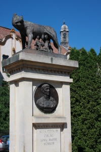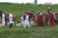


Zalau Porolissum Roman Festival
Ancient sites
Archaeological sites identified on Zalău territory
Situated in the heart of Sălaj county, Zalău municipality developed as a human settlement on the western foothills of Meseş mountains, near the pass "Porta Mesesina - Poarta Mesesana", a natural passing between the Upper Tisa area and Transylvania. This character of a passing area is obvious also through the great number of archaeological discoveries, find by chance or as a result of researches since the late 19th century. A part of the Meseş mountains belong to Zalău; in this area the Romans built a magnificent defensive system (the Roman Empire's limes) yet insufficiently known and researched.
Most of the known archaeological sites from Zalău area were identified during the researches that focused on the mapping and description of the Roman frontier on the Meseş Height, but also during the preventive research from the current industrial area of the city, after 1968. Preventive researches were also made in the central area of the city, on the streets C. Coposu (former Republicii), Unirii, the food market area; systematic excavations were made in Valea Miţii and at the limit of the administrative territory of the city, towards Hereclean village.
On the Meseş Height but also to the basis of the mountain, the Romans built a complex defensive system consisting of small soil fortifications, burgus type walls, defensive and signaling towers and also waves with grooves (clausurae) or walls. Behind Meseş mountains towards Transylvania the defensive system had a line of Roman fortresses (castra), the headquarters of the Roman troops who had the main role of defending this defensive line also known in the specialty literature as limes Porolissensis. Part of the Dacia`s limes from mount Meseş belongs to the present administrative territory of Zalău municipality.
This is a brief description of the ancient constructions found on the administrative territory of Zalău municipality, description that can also be a guide for a walk on the defensive line developed by Romans on Meseş mountains:
- 1. In the downtown area, on C.Coposu street (former Republicii), between 1987 and 1988, when some utility works were made, there were also carried out some archaeological surveillance works and rescue excavations in the area of the buildings no. 21 to 23. At a great depth (-1.10m - 1.30m) due to erosion deposits on the hill slope (Kossuth street), it was identified a level of Roman age corresponding to a settlement located in Barbaricum (area non-occupied by Romans, where Dacians lived), in the close proximity of the Roman border on Meseş. In the same area, after the 2nd world war, it was discovered by chance a Roman denarius. It seems that the habitation in the Roman era was focused on the junction of the creek flowing from the current street Coposu with Olarilor creek.
- 2. On the top of the Păstaie peak on the Meseş mountaintop, at approximately 1000m on the right of Zalău-Cluj road, near the carriage path, there is a Roman tower that was entirely destroyed by the treasure hunters at the end of the 19th century and as a result of the stone exploitation. From this point, on the south - south western part of the mountain slope descending to the lower area, on the mountain ridge, it can be noticed a relatively well preserved wave of flattened land having approximately 6m wide with a approx. 6 to 8m ditch. The ditch is visible to the west - south west, on a total length of about 1.5 km. The linear path of this wave takes a turn to the south west, at approx. 950m south from Păstaie peak, thus changing its direction a few degrees. In this point precisely, behind the wave, at approx. 15 - 20m, there is a large isolated elevation, with a very big hillock shape, having the height of approx. 3-4m and the base diameter of about 25-30m, which indicates the presence of a tower.
- 3. The line of Roman fortifications from Meseş peak continues with the objectives researched on Măgura Stânii. One of the Roman towers seems to have been destroied during the construction of the Radio-TV relay building. Roman tiles and bricks discovered during the construction of the tower got to the Museum of Zalău in 1968-1970. During the last years (2003 - 2007) in this area there were build some relays for mobile communication. In the summer of 2002 another Roman tower, located at about 300 m north-north-east from the relay building and 2m from a relay`s mobile communication fence was sectioned. It seems that in Măgura Stânii area there was human presence older than 2nd - 3rd century AD (since the Roman tower dates), the proof being the ceramic from the first Iron Age and Laténe period discovered during the 2002 excavations.
- 4. The Meses mountaintop descends to the north of the "Sub Măgura Stânii" area. Ruins from another Roman tower are found approximately 400 m north, north-east from the last mobile phone antenna enclosure, near the road that partially cuts the east tower's ditch. The tower, that had 6 x 6 m size, and a circular ditch surrounding it, is situated near the road and had a very good visibility until the base of Mount Meses.
- 5. The ruins of another tower, known as "La Oroieşi - Huda Oroieşilor", were found approximately 500 m north from the last mentioned tower (from the "Sub Măgura Stânii" area), in the forest, 10 m from the east side of the forest road that leads to the Stâna village. This tower had the same size and good visibility like the previous. It seems that the tower was partially destroyed because of the rock exploitation, hence the large number of holes.
- 6. Another Roman tower, located on the administrative territory of Zalău, can be found approx. 500 m south from the Druia main peak, towards Măgura Stânii. Its ruins are located 700 m south from the path that leads from Zalău to Stâna, respectively 15 m west from the carriage road. The tower had a rectangular plan, with a size of 8 x 8 m and a circular ditch surrounding it. A geodesic landmark can be found on the west side of the tower. The ruins are well preserved. The interior walls can be seen thanks to the 1970 archaeological diggings.
- 7. Another tower was found between the "Druia" and "Poiană" peaks, on the ridge that descends towards Moigrad. These ruins are the most imposing and the biggest Roman tower ruins from Meseş. The tower is located on the ridge of Mount Meseş, approx. 150 m west from the mountain spring water catchments tanks area, which supplied water to the military and civil centre of Porolissum. It is believed that, beside the distribution of signals to the Roman military centre from Porolissum, the tower had also a defence purpose (for the catchments tanks).
- 8. Another Roman tower was found at "La Poiana de Sus", aprox. 500 m north from the "Druia" area, at the spring of "Valea Cabii" that flows towards Ortelec, at the forest edge. In the XVIII-XIX centuries, a "unicellular house" was built on the east side of the tower ruin, south-east towards the mountain slope. The house had a rock and roof tiles' remains foundation, Roman bricks and fragments of clay pipes. A very big furnace - fireplace was discovered in the north corner of the house (preliminary results of a testing survey from spring 2009).
- 9. Another tower, located behind the same Roman wall presented above, was researched through archaeological diggings approx. 300 m north from the tower located at the spring of "Valea Cabii". The ruins of the tower are situated approx. 50 m on the pasture near the edge of the forest. The ruins appear as an artificial circular mamelon/ hillock higher with approx. 3 m than the current level of the land and have a total diameter of approx. 40 m, including the defense ditch. The ruin was studied in the summer of 1997. The tower had a circular form with a 6 m interior and 0.80 m walls. Based on its strategic location, as the tower from the spring of "Valea Cabii", the purpose of the tower was the surveillance of the visible sector of the wall and the nearby defense ditch, as well as the access to the valley, the water tanks and the pipes of the Porolissum aqueduct.
- 10. From the spring of "Valea Cabii" towards north, north-east, approx. 400 m near the forest edge and 200 m on the "Dealul Porcarului" pasture, the wall and Roman defense ditch has approx. 600 m of linear duct. The line of this wall forms the administrative limit of Zalău City. The wall and defense ditch belong to the Roman defense system of the "Poarta Meseşană" (the access to Transylvania) and the water sources (collecting tanks and water transportation pipelines).
- 11. The ruins of a Roman tower can be found in the middle of the eastern slope of "Dealul Corniştea". The ruins look like a circular ring, having its middle deepened and its edges raised with approx. 0.50-1 m. The exterior diameter measures approx. 15-20 m. "Dealul Corniştea" has a perfect visibility in every direction.
- 12. The wall with its south ditch follows the ridge of "Dealul Corniştea" on its length of approx. 250-300 m until it meats "Dealul Dojii". On the west slope of "Dealul Corniştea", the wall and the ditch are well highlighted on the field. The ditch's area from the east slope and from the top of "Dealul Corniştea" is highly damaged because of the limestone exploitation for lime manufacturing. Signs of ovens used to burn the limestone can be spotted.
- 13. The Roman defense system from "Dealul Corniştea" continues on the west slope of "Dealul Dojii", entering the forest known as "Pădurea de pe dealul Măguriţa". A Roman tower was discovered south from the edge of the forest. It is situated in the continuation of the ditch and wall that have the linear duct on "Dealul Corniştea" and "Dealul Dojii". The tower has a circular form, deepened in the middle, with a diameter of approx. 6-8 m, and slightly raised edges.
- 14. On the top of "Măguriţa" hill, the first top from east and closest to the former Ortelec village (presently residential area of Zalău), above the houses situated in the pass ("La Strâmtură") lies another Roman tower with a square plan.
- 15. A Roman wall (clausura) of approx. 250 m long is found between "Măguriţa" and "Valea Ortelecului", on the north slope from the foot of the "Măguriţa" hill, in the narrowest point of the "Poarta Meseşană" pass, known as "La Strâmtură", above the deep glen of the springs known as "Fântâna Suşigului". This wall was blocking the pass and continued on the left shore of the Ortelec valley until the "Poguior" hill, where another Roman tower was found, the wall continuing towards Mirşid and Poeni. A part of this wall is situated on the administrative territory of Zalău. The northern part of the wall stops on the terrace from above the Ortelec valley, in the south-west corner of the rectangular Roman wall fortification, fortification of "burgus" type, forming a common body. The wall continues linearly from the north-west corner of the fortification, perpendicularly over the Ortelec valley, thus blocking the valley's width of approx. 150 m.
- 16. A Roman burgus (Roman military fortification with pass circulation control) was located on the Ortelec valley, at the exit of Ortelec village, on the right side, in the "Fântâna Suşigului" point, attached to the wall presented above. Approx. a third of the fortification width is located at the edge of the forest, the rest being within. The Roman fortification had a quadrilateral shape, with sides measuring approx. 55 x 50 m and was attached to east and west by the provincial wall (clausura) described above.
- 17. At least 12 mounds/ hammocks are found in the "Acastauă", "Dealul Pietroasa 1 - 2" and "Dealul Mare" points, situated in the forest from the north-west part of the town, north to the Zalău-Moigrad-Jibou road, in the contact area between the administrative territories of Zalău and Mirşid commune. There are at least 2 significant groups of anthropogenic mounds that can be considered funerary constructions (tumuli) dating from a historical era that is difficult to establish because of the lack of archaeological research.
- 18. Another Roman tower is located in Zalău, near "Masa Craiului", at the north-eastern end of the former Patriotic Guards' polygon. The tower is located in the forest known as "Hotlo". A small fortification is found on the pasture, under the "Hotlo" forest.
- 19. A well preserved Roman tower of large dimensions was identified on the pasture, in the "Clocoţăl" area, from the Ortelec neighborhood. It has the shape of a raised mamelon with a deepened middle.
- 20. Also in the Ortelec neighborhood, at "Crecuta-Fânaţe", the preventive archaeological research has led to the discovery of a settlement that is believed to belong to the Roman era.
- 21. Another site from the Roman era was found on the right shore of the Miţii valley, in the floodable area on a slightly raised terrain, at the base of the terrace between the neighborhood Valea Miţii and the village Aghireş, 200 m from the two isolated houses.
Al. V. Matei's latest research has led to the identification of a new line of Roman towers that are part of the northwestern Roman Empire Limes.
A series of isolated discoveries are known from the old literature that could indicate the existence of archaeological sites from the Antiquity:
- A bronze axe was discovered during some constructions made in the Military Unit's yard in 1960.
- A fragment from a bronze axe was discovered in 1955 in the yard of the current "Simion Bărnuţiu" school.
- A rock axe was accidentally discovered in 1954 on Kossuth Street, near the no. 11 house.
- In 1960, on Olarilor Street, in unknown conditions, a rock axe was discovered.
- In 1975, a rock axe was discovered in the Balaszi tanya/Magyoros area (the orchard towards Aghireş village). The research from 2010 for identifying the site led to the collection of some ceramic fragments from the Roman era and an obsidian splinter. The splinter and the axe indicated the existence of a prehistoric and Roman site.
- A silex blade was found in 1971 on the Stadium.
- An obsidian core was discovered in 1971 during the construction of the Agronomist House on C. Coposu Street.
- A rock chisel was discovered during some works made behind the Meseş Galleries.
(The above information was provided by the Zalău County History and Arts Musem)
 Subscribe via RSS